-
Latham Copper-Gold Project
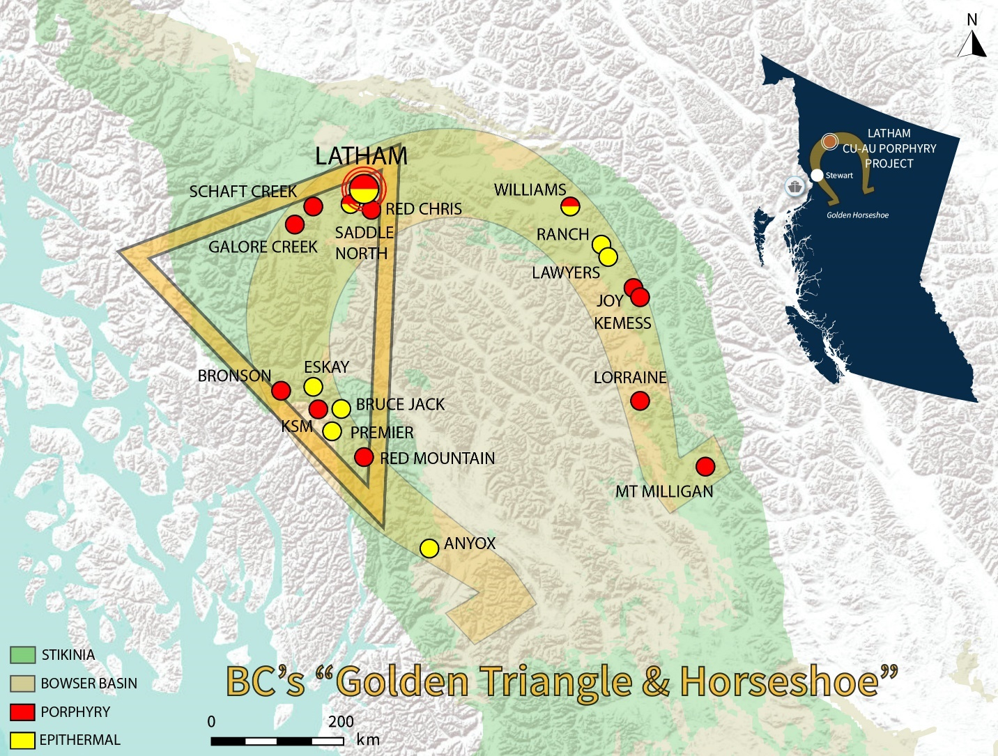
The district-scale Latham Copper-Gold Project covers a district-scale 689 km2 within the prolific “Golden Triangle” region, a section of the “Golden Horseshoe” arc of gold and polymetallic mineralization within the highly prospective Stikine terrane rocks of northern British Columbia, Canada (Figure 1). This region is also host to a number of proximal major copper-gold porphyry deposits along-trend to the southwest including the Red Chris, Saddle North, Schaft Creek, and Galore Creek deposits. The Golden Triangle and Horseshoe concepts provide a visual context for the mines, discoveries, and geological trends that concentrates porphyry and epithermal mineralization throughout the Stikine terrane.

Figure 1. Map of the Golden Triangle and Latham project location.
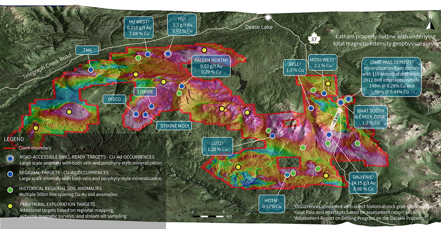
The town and regional airport of Dease Lake is located approximately 16 kilometres (km) north of the property boundary along Highway 37, which transects the eastern portion of the property. The project is well situated within a north-northeast trending copper-gold porphyry trend that is highly attractive to major mining companies within a 40 km and 150 km radius to the south; including Newcrest Mining and Imperial Metals (Red Chris Project), Newmont Corporation (Saddle North, Galore Creek, Schaft Creek Projects), and Teck Resources in partnership with Newmont Corporation at Schaft Creek (Figure 2).
Located on the Latham project is the Gnat Pass deposit, the last developed prospect in the region not advanced since its discovery alongside Red Chris, Schaft Creek, and Galore Creek during British Columbia’s 1960’s porphyry rush (Figure 2). Although historical drilling showed that mineralization remained open along-strike and beyond 150 metres vertical depth, Gnat Pass was deemed too small for further development. However, the surface footprint is comparable to the recent discovery of the Saddle North deposit which was first drilled in 2017 and acquired by Newmont Corporation in 2021. As such, the Gnat Pass deposit provides both excellent growth potential as well as a model for future potential discoveries throughout the district-scale Latham property, which contains an additional 13 known mineral occurrences and 19 exploration targets at various stages of advancement.
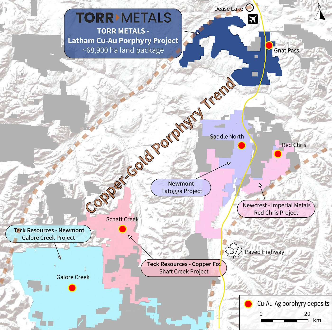
Figure 2. Project map (2022) with local infrastructure and surrounding major projects.
Project History
The Latham property and surrounding area has an exploration history dating back to the Dease Lake gold rush in 1899, followed by concentrated exploration activity during the 1960’s that led to the delineation of the Gnat Pass copper-porphyry deposit and mineral occurrences at Dalvenie and Hu. Since 1960 there has been at least 14 operators that have conducted a significant amount of work on claims that now constitute the Latham property, including the first regional exploration from 2011 to 2013 that identified an additional 11 mineral occurrences (Figure 3).
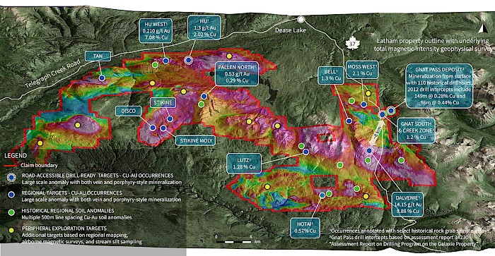
Figure 3. Location of mineral occurrences and Gnat Pass deposit at Latham.
Historic Drilling – Defining Multiple Copper-Gold Porphyry and Epithermal Systems
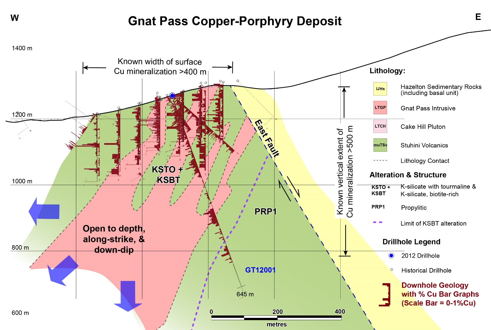
The majority of historical drilling on the property is dated to the 1960’s at the Gnat Pass deposit. In total the Gnat Pass deposit area has been tested by 111 drillholes, with the most recent 2012 drilling consisting of two drillholes within the main deposit (Table 1). For the first time 2012 drilling extended mineralization from 150 metres to over 500 metres vertical depth, with the deposit remaining open to expansion in width, depth, and along-strike to the north. This suggests that there is significant potential to expand the deposit and establish a modern resource at the Gnat Pass deposit (Figure 4).
Table 1. Select drill intercepts from 2012 drilling at the Gnat Pass deposit.
Zone Intercepts from 2012 Drilling at Gnat Pass Gnat Pass 35 metres @ 0.29% Cu from 29 metres depth in drill hole GT12001 Gnat Pass 149 metres @ 0.28% Cu from 95 metres depth in drill hole GT12001 Gnat Pass 56 metres @ 0.44% Cu from 360 metres depth in drill hole GT12001 Gnat Pass 21 metres @ 0.35% Cu from 487 metres depth in drill hole GT12001 Gnat Pass 103 metres @ 0.34% Cu from 94 metres depth in drill hole GT12002 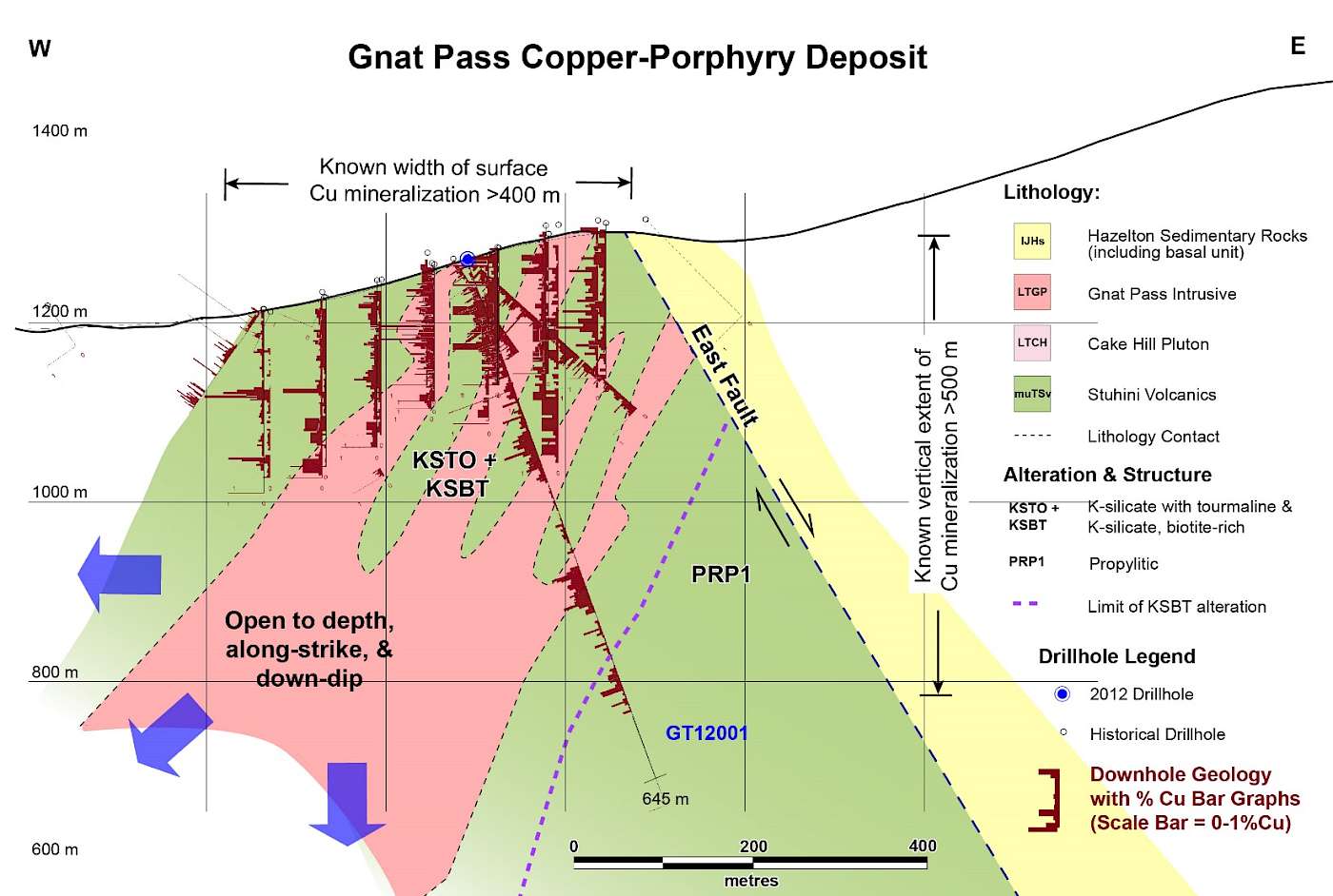
Figure 4. Cross-section with displaying historical 1989 and 2012 drilling at Gnat Pass deposit.
Historical drilling only tested the southern half of a copper-in-soil anomaly that remains open to the north at the Gnat Pass deposit. There are also two peripheral copperin-soil anomalies that were never directly drill targeted, suggesting the potential for a larger porphyry cluster footprint to the Gnat Pass system. Details of the peripheral soil anomalies are provided below:
- Located ~1 kilometre west of the Gnat Pass deposit is the Creek Zone, a north trending >100 ppm copper soil anomaly measuring approximately 150-200 metres east-west by 600 metres north-south; the copper soil anomaly remains untested by drilling.
- A north trending >100 ppm copper anomaly situated ~650 metres southwest of Gnat Pass in the valley bottom between the Gnat Pass deposit and the Creek Zone. This zone measures approximately 150 metres east-west and 300 metres north-south and remains untested by drilling and open to expansion with additional soil sampling.
The only historical drilling on the property outside of the Gnat Pass area targeted surface mineralization in 7 shallow drill holes from 1968 at the Dalvenie copper-gold occurrence, located ~8 km southwest of the Gnat Pass deposit. Results of the 1968 drill program were reported without known depths by Matich (1990) and are outlined below in Table 2.
Table 2. Select drill intercepts from 1968 drilling at the Dalvenie occurrence.
Zone Intercepts from 1968 Drilling at Dalvenie Dalvenie 2.2 metres @ 0.89% Cu and 3.4 g/t Au in drill hole 68-3 Dalvenie 8.3 metres @ 0.40% Cu and 0.62 g/t Au in drill hole 68-10 Dalvenie 1.5 metres of 3.73% Cu and 4.8 g/t Au in drill hole 68-11 Follow-up work conducted at Dalvenie during the late 1980’s defined an approximate 1,000 metre long by 150 metre wide copper soil anomaly that remains untested and to the north along-strike of historical drilling, coincident with the extensive Dalvenie shear system. This zone is paralleled by an additional 750 metre by 250 metre copper-in-soil anomaly located 400 metres to the east that is also untested by historical drilling. These results suggest significant upside potential for further exploration at the Dalvenie occurrence.
Stratigraphy
The Latham property is predominantly underlain by the Late Triassic Stuhini Group, consisting of submarine basaltic to andesitic volcanics, volcaniclastic, and sedimentary rocks (Figure 5). Sections of the property also contain exposures of Latest Triassic to Early Jurassic Hazelton Group composed of a diverse assemblage of bimodal basaltic to rhyolitic subaerial and submarine volcanic rocks with related sediments.
Intruding the Stuhini and Hazelton Group host rocks is a series of Late Triassic to Early Jurassic syenite and diorite to quartz monzonite stocks and dikes that appear genetically related with mineralization at known mineral occurrences throughout the property. Regionally, significant porphyry and epithermal mineral deposits hosted within Stuhini and Hazelton Group host rocks are related to this age of intrusions and volcanogenic hydrothermal activity (Figure 5).
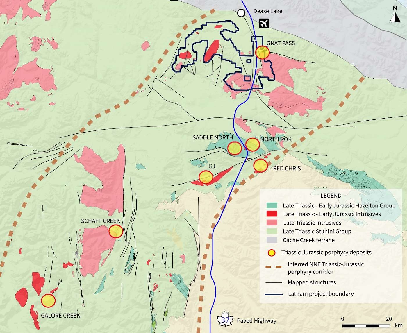
Figure 5. Regional host rock geology and the Latham Copper-Gold Project location.
Structure
Host structures for the Hu, Pallen, and Dalvenie mineralized trends were likely long-lived, as with a number of the significant porphyry and epithermal deposits within the region (Figure 6). Lying within the ~20 km long Dalvenie trend, the Gnat Pass copper-gold porphyry deposit is hosted within the composite Gnat Pass stock; consisting of multiple phases of structurally-controlled north and east-trending clustered porphyries that defines a pattern identified at multiple targets throughout the property.
Primary north-trending mineralization, as seen at Gnat Pass and Dalvenie, suggests association with potential north-striking basement lineaments that would have provided transcrustal magma and fluid pathways for Late Triassic intrusions. Secondary subsidiary east-striking cross faults, seen overprinting primary trends in the Gnat Pass deposit, likely provided the pathways for Latest Triassic to Early Jurassic east-trending intrusions, alteration, hydrothermal veins, and metal distribution. East-trending mineralization and alteration associated with Early Jurassic intrusions has also been defined at multiple exploration targets including Hu, Pallen North, and Thenatlodi.
Late Triassic to Early Jurassic structures likely also influenced the geometry of later northwest and northeast-trending Cretaceous structures that locally offset the pre-existing north and east-trending mineralizing systems. These structural relationships are evident in outcrop as well as magnetic and induced polarization (IP) geophysical surveys that cover portions of the property, suggesting significant potential for future copper-gold porphyry discoveries exist beyond the Gnat Pass deposit.
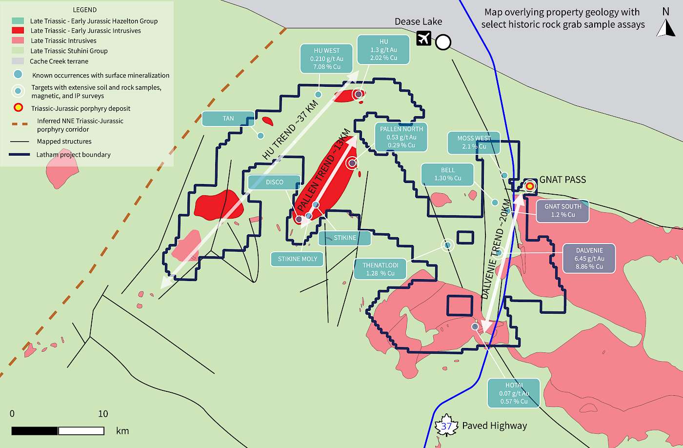
Figure 6. Primary mineralized trends and known mineral occurrences on the Latham property.
Alteration and Mineralization
Surface mineralization at a number of advanced occurrences, including the Gnat Pass deposit, is coincident with widespread carbonate-sericite alteration as well as localized silicification and advanced argillic alteration within host Stuhini volcanic rocks and Late Triassic to Early-Jurassic intrusions. Metal distribution and alteration zonation patterns include pyrite-chalcopyrite-galena-molybdenum in polymetallic veining and increased distribution of As-TI-Bi-Se-Te-Sb-Mo hydrothermal alteration assemblages. These alteration zones are also typically coincident with anomalous rock +/- trench results, moderate to high electromagnetic and magnetic anomalies, and large copper-in-soil anomalies. This would suggest that exposure on the Latham property is typically above or within the upper portion of the mineralized zone in a porphyry system, a conclusion supported by the intersection of mineralization in drill core from surface to over 500 metres vertical depth at the Gnat Pass deposit.
In addition to porphyry systems, Torr’s substantial historical database suggests the Latham property is highly prospective for potential epithermal-style base and precious metal mineralization as well as contact zone and skarn-style mineralization.
QP Statement
Michael Dufresne, M.Sc., P.Geol., P.Geo., serves as a Technical Advisor and is the Qualified Person, as defined by National Instrument 43-101, responsible for reviewing and approving the technical content of all materials publicly disclosed by Torr, including the contents of this website.