-
Kolos Copper-Gold Project
District-Scale Discovery Opportunity in the Quesnel Trough, British Columbia
The 100%-owned Kolos Copper-Gold Project (~275 km²), together with the strategically optioned Bertha Property (57 km²), form a highly prospective 332 km² land package within the Quesnel Terrane. This prolific porphyry belt in southern British Columbia hosts several major copper ± gold deposits, including the nearby Highland Valley, New Afton, and Copper Mountain mines.
The Project is underlain by Nicola Group volcanic rocks intruded by coeval diorite to monzonite and younger granodiorite phases. Mineralization is structurally controlled along the north-trending Fanta Fault and associated northwest- and northeast-trending structures, which act as key conduits for hydrothermal fluids and intrusive emplacement.
Kolos benefits from excellent infrastructure, including direct access via Highway 5 and 97D and proximity to the city and local mining hub of Kamloops, enabling efficient, year-round exploration.
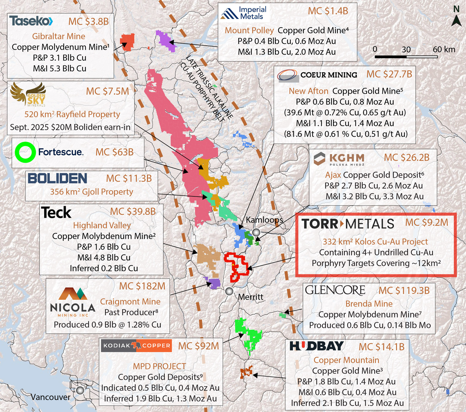
1Gibraltar: Taseko Reserves and Resources Website Information, accessed August 21, 2025
2Highland Valley: Teck Mineral P&P, M&I, Inferred Resources Annual Information For February 23, 2022 (Teck.com)
3Copper Mountain: Mineral Reserves and Resources as of January 1, 2025. (hudbayminerals.com)
4Mount Polley: Imperial Metals P&P, M&I, Inferred Resources Reserves and Resources; Website Information, dated June, 2023 (www.imperialmetals.com)
5New Afton: NI 43-101 Technical Report. Effective Date December 31, 2024. (newgold.com)
6Ajax: KGHM Mineral Resources and Reserves Report. as of December 31, 2014. (kghm.com)
7Weeks et al., 2003. The Brenda Mine in Porphyry Copper Deposits of the Calc-Alkalic Suite Paper 9 of the Porphyry Deposits of Northwestern Cordillera of North America, CIM Special Volume 46, pp 192-200
8Wells KW, Gray JG. 2020. NI 43-101 Technical Report on the Preliminary Copper Resource for the Southern Dump and 3060 Portal Dumps. Effective Date May 21, 2020. (nicolamining.com)
9Rodriguez et al. 2025. Technical Report and Mineral Resource Estimate MPD Project British Columbia, Canada. Effective date December 9, 2025. (kodiakcoppercorp.com)Disclaimer
The Company notes that mineralization hosted on adjacent and/or nearby properties is not necessarily indicative of mineralization hosted on the Kolos Project.
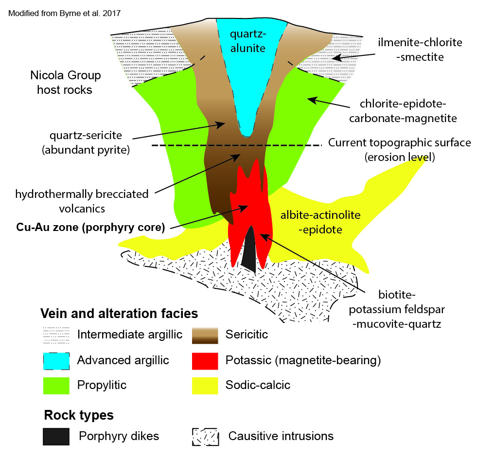
GEOLOGICAL SETTING
The Kolos Copper-Gold project is situated within the Quesnel Terrane, characterized by Late Triassic arc magmatism and associated porphyry copper-gold mineralization.
Key lithologies include:
- Nicola Group andesitic volcanics (flows, tuffs, breccias)
- Diorite to quartz diorite intrusions interpreted as subvolcanic feeders
- Jurassic granodiorite batholiths (Coast Intrusive Complex)
The Project is transected by the Fanta Fault, a major north-trending structure separating volcanic and intrusive domains. Secondary northwest- and northeast-trending structures provide key controls on:
- Fluid flow and alteration
- Sulphide deposition
- Localization of mineralized zones
Alteration assemblages include propylitic (epidote–chlorite ± carbonate), widespread phyllic (silica ± pyrite ± chalcopyrite), and localized potassic (biotite ± potassium feldspar) assemblages indicative of exposure levels consistent with the upper to transitional portions of porphyry systems.
BERTHA SYSTEM
Vectoring from Hydrothermal System to Porphyry Source
The Bertha area represents a newly identified copper-bearing hydrothermal system with clear vectors toward a causative porphyry intrusion.
Hydrothermal System (Bertha)
- First Ever Phase I drilling (~2,700 m) completed in December 2025 intersected a vertically extensive hydrothermal native copper system to ~580 m depth
- Native copper mineralization occurs along a moderate dipping picrite unit, interpreted as a structurally controlled geochemical (reducing) trap within a broader fluid pathway
- Alteration characterized by chlorite–epidote ± carbonate ± silica, with increasing intensity and veining to the northwest and northeast
Geological interpretation:
- Native copper and low sulphide content suggests a distal to transitional environment along a northwest-striking leakage structure linked to an alkalic porphyry system
- Structural preparation along the picrite unit facilitated fluid flow and metal deposition at key structural intersections
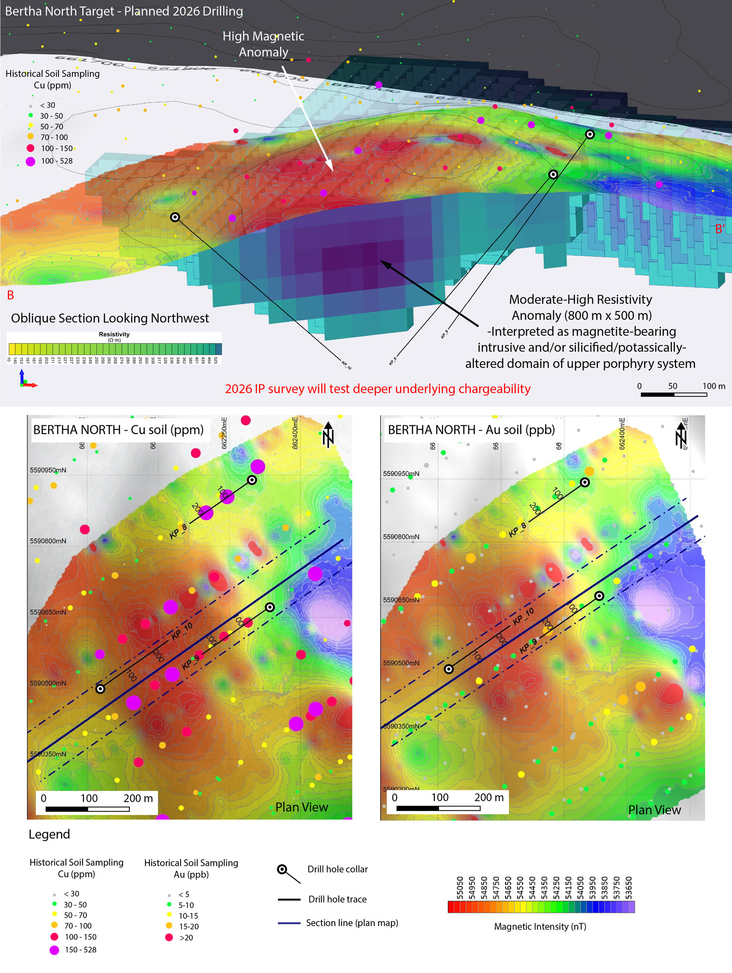
Source Target (Bertha North)
- Located immediately along-strike to the northwest at a higher structural level within the same system where the picrite contact steepens, providing improved prospective architecture
- Large resistivity geophysical anomaly interpreted as a silica-altered intrusive body, a signature not yet tested in the Bertha area
- Coincident moderate chargeability anomaly at depth suggests development of primary (hypogene) disseminated sulphides (chalcopyrite ± bornite)
Additional supporting vectors:
- 800 m x 500 m Cu-Au soil anomaly directly overlying the geophysical target
- Position at intersection of northwest- and northeast-trending structures, enhancing permeability and focusing mineralization
Integrated Interpretation
The Bertha hydrothermal system and Bertha North target are interpreted as part of a single mineralized system, where:
- Bertha represents the distal expression of copper-bearing fluids
- Bertha North represents a higher temperature zone proximal to the causative intrusive source
Ongoing work is focused on:
- Step-out and deeper drilling to transition from native copper zones to sulphide-bearing hypogene mineralization
- Geophysical refinement of chargeability and resistivity anomalies
DISTRICT-SCALE NORTHERN CORRIDOR
>10 km of Undrilled Porphyry and Epithermal Potential
A major northwest-southeast structural corridor extends over 10 km across the northern portion of the property.
- Hosts multiple mineral occurrences and coincident geophysical anomalies
- Geologically analogous to the Iron Mask Batholith and New Afton/Ajax systems*
- Spatial association with intrusive centres and alteration zones
The scale and continuity of this corridor suggest potential for multiple porphyry centres within a district-scale system.
Disclaimer
Information and comparisons disclosed is not necessarily indicative of precious or base metal endowment or assays on the Kolos Project.
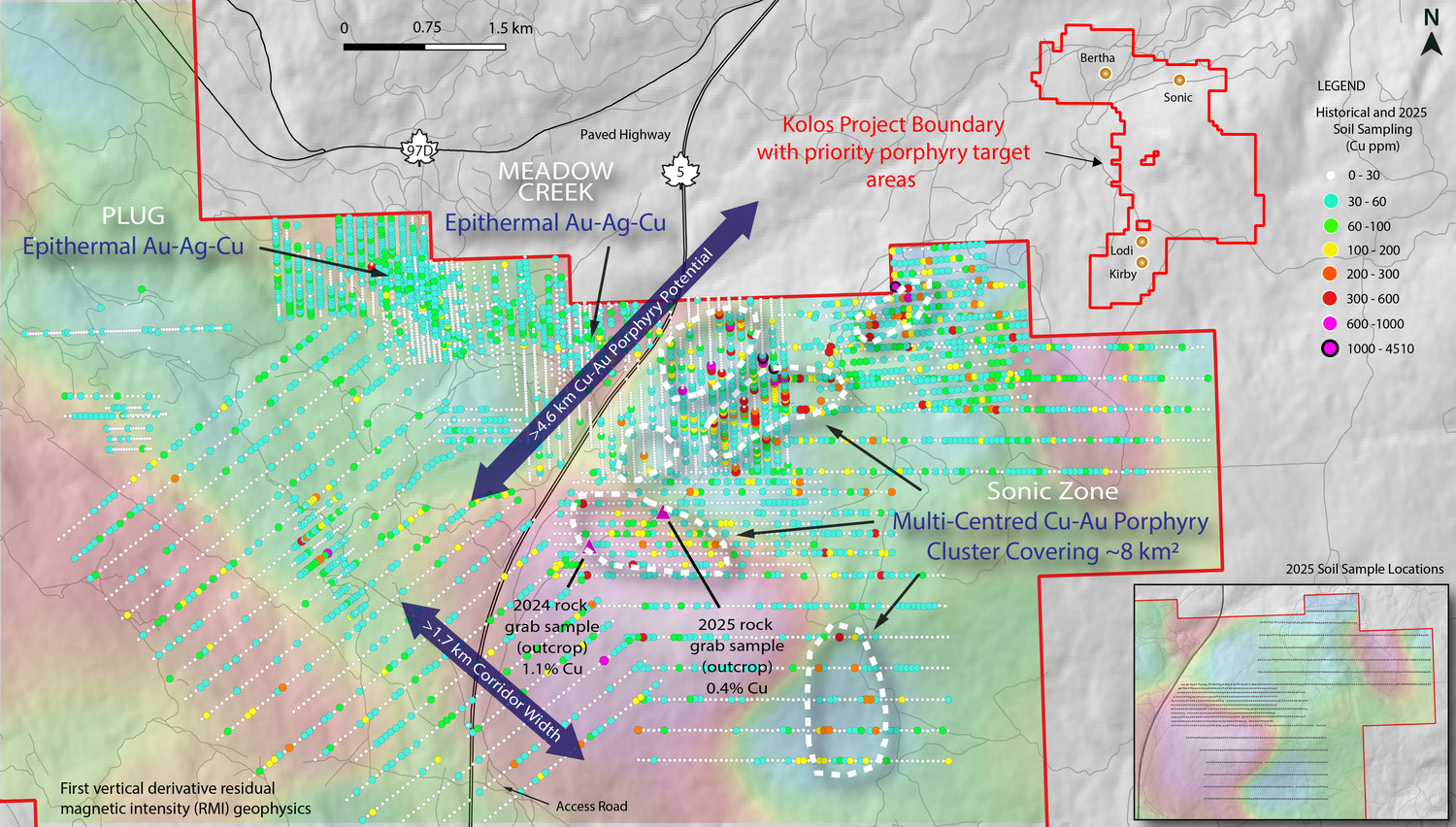
SONIC TARGET
Large-Scale, Undrilled Porphyry System
The Sonic target is defined by a broad, multi-centre geochemical anomaly and associated geophysical features.
- ~8 km² copper-gold soil anomaly with values up to 4,510 ppm Cu and 420 ppb Au
- Coincident with interpreted intrusive centres and structural intersections
- Geochemical signature consistent with porphyry-related mineralization
Interpretation:
- Represents a fertile intrusive complex with potential for multiple mineralized centres
- Comparable in scale and geological setting to the Ajax deposit ~30 km to the northeast
Disclaimer
Information and comparisons disclosed is not necessarily indicative of precious or base metal endowment or assays on the Kolos Project.
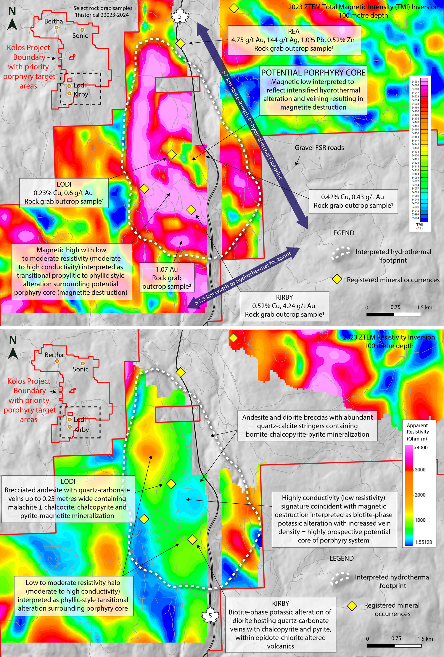
KIRBY–LODI TARGET
Large Hydrothermal System with Concealed Porphyry Potential
The Kirby-Lodi area hosts a large, well-defined hydrothermal system with strong evidence for a concealed porphyry core.
- 24.5 km² alteration footprint defined by magnetic, resistivity, and geochemical datasets
- Magnetic destruction coincident with conductive core and resistive halo typical of porphyry alteration zonation
Geochemical zonation indicates a complete porphyry system:
- Core: Cu-Au (chalcopyrite ± bornite)
- Inner shell: Mo-Bi-Te
- Outer shell: Ag-Pb-Zn
- Peripheral halo: As-Sb
Rock sampling supports mineralization:
- Select rock grab samples up to 0.52% Cu and 4.24 g/t Au from intrusive-hosted mineralization in outcrop
These features are consistent with a leakage halo above a buried porphyry centre.
EXPLORATION UPSIDE & SUMMARY
The Kolos Project combines the key elements required for significant brand-new copper-gold porphyry discovery potential with existing provincial and mining infrastructure access:
- District-scale land package in British Columbia’s premier copper-producing belt with assets owned by nine major mining companies
- Three defined cluster-style porphyry zones (Bertha, Sonic, Kirby–Lodi) with <3,000 metres of drilling to date at Bertha
- Confirmed large-scale hydrothermal system with clear vectors to potential source (Bertha → Bertha North)
- Multiple high-quality, undrilled targets across a structurally controlled corridor
- Strong structural, geophysical, and geochemical vectors supporting interpreted mineralized centres
- Geological analogues to nearby producing and past-producing deposits (e.g., New Afton and Ajax-style systems)
- Excellent infrastructure and year-round access
- Active geophysics and upcoming drilling in 2026 designed to rapidly advance targets
Disclaimer
Information and comparisons disclosed is not necessarily indicative of precious or base metal endowment or assays on the Kolos Project.