-
Filion Gold Project
Located in the boundary region of the Wawa and Quetico geological subprovinces of Ontario, the 100% owned 261 km2 Filion Project lies within a largely underexplored greenstone belt where gold was first discovered during the 1930’s. Within the greenstone belt the Filion Project encompasses the major Filion Deformation Zone that extends along a 42 kilometre (km) east-west trend, establishing a geological setting comparable to early syn-volcanic aged Archean gold deposits within the region including the Hemlo, Greenstone, Casa Berardi, and Detour Lake mines (Figure 1).
Additionally the road-accessible Filion Project is ideally situated with excellent access to substantial infrastructure including the Trans-Canada Highway and paralleling regional railway and power grid 4 km to the south, as well as the nearby town of Kapuskasing (pop. 8300). As a result the Filion Project is uniquely positioned for low-cost year-round operation potential within an underexplored region ripe with new discovery potential (Figure 1).
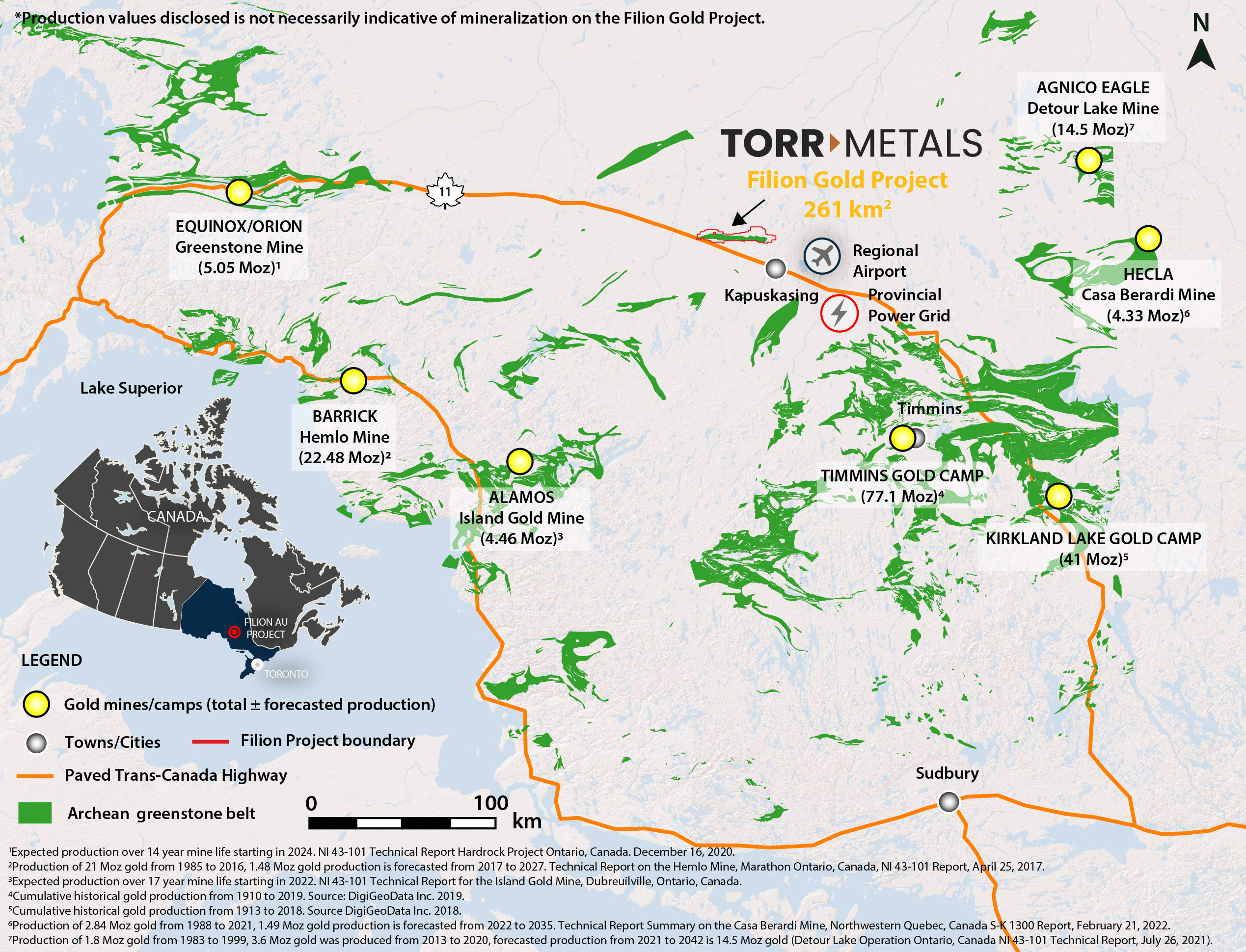
Figure 1. Filion Project location within the prolific gold-endowed greenstone belts of the Wabigoon, Wawa, and Abitibi subprovinces of northern Ontario. Figure includes the positions as well as total historical and forecasted production of major regional gold mines.
Project History - Gold Identified but Never Systematically Explored
Prior to 1987 the majority of exploration work in the area was conducted by individual prospectors who discovered gold in quartz veins associated with pyrite-arsenopyrite mineralization during the early 1930’s at the Oscar occurrence. By the mid-1930’s the number of gold occurrences had increased to include the Huna and Miller East occurrences (Figure 2) with significant gold assays being reported. Locally concentrated trenching followed and in 1945 Valrita Mines Limited completed a ground magnetometer survey covering portions of the historical occurrences, noting “several pronounced anomalies” (1948 Magnetometer Survey File ID 42G10SE0004).
In 1948 J.M. Andercheck drilled 5 inclined diamond drill holes totaling ~380 metres approximately 780 metres northeast of the Miller East occurrence and although no assays are given he describes Hole 1 cutting a “15 foot (~4.5 metre) wide ore body at a depth of ~33 metres (1948 Diamond Drill Report File ID 42G10SE0006).
In 1958 approximately 248 metres of diamond core drilling was conducted at the Teho occurrence (Figure 2) and surrounding area to the west (Drill Report File ID 42G10SW0011). Drill logs from drill holes (DH) 58-7 and 58-8 both report intercepting a sulphide zone within interbedded quartz sericite schist, gneissic amphibolites, and greenschist facies metasediments (Figure 2). Drill hole 58-7 reported quartz veining and replacement sulphides within metasediments from 48.8 metres to 89.9 metres. Within this interval is a section of enhanced quartz veining (~60% of core) with chlorite, epidote, silica alteration and pyrrhotite-pyrite-chalcopyrite (predominantly pyrrhotite) mineralization that yielded trace gold and silver from 70.1 metres to 89.9 metres. Although follow-up drilling was never conducted the style of alteration and mineralization together with the close spatial relationship to faulted stratigraphic contacts and shear zones represents a favourable geological setting comparable to the Lower Detour Lake Formation contact with the Sunday Lake Deformation Zone, which hosts the Detour Lake mine1.
In 1985 D. Korpela of Northland Exploration Ltd. completed ground magnetometer and VLF-EM surveys over the surrounding area on behalf of Romex Resources and Omab Enterprises, outlining 48 highly prospective east-northeast and east-west conductors (1985 Magnetometer and VLF Survey on the McCowan Gold Property, File ID 42G10SE0002). At this time L. Luhta, a Resident Geologist for the Ontario Ministry of Natural Resources in Timmins visited the property and collected a rock grab sample from a historical trench at the Oscar occurrence that yielded 9.1 g/t gold2. Following in 1987 Robert G. Smith carried out an overburden stripping program at the Keevil Road, Keevil, and Miller East occurrences reporting exposures of quartz and arsenopyrite as well as quartz-feldspar porphyry and metasediment contacts with anomalous gold values (File ID 42G10SE0003).
In 1987 Robert G. Smith conducted 298 metres of core drilling in the vicinity of the Keevil Road and Keevil occurrences (Figure 2) and although no assays were reported drill hole (DH) 88-7 reported descriptions of strong hydrothermal alteration in the drill logs that could be permissive for precious metals. This included the following:
Quartz veining associated with variable amounts of pyrite-arsenopyrite mineralization and silica-sericite-tourmaline alteration hosted by metasediments from 16.7 metres to the end of hole at 89.9 metres. Veining and alteration is associated with contacts between metasediments and a quartz-feldspar porphyry. Within this interval a section from 49.4 metres to 60.3 metres is reported to contain extensive quartz veining with moderate to strong silicification and sericitization together with enhanced pyrite-arsenopyrite mineralization. These styles of historically reported alteration and mineralization together with the lithological and structural characteristics were confirmed by 2023 channel sampling of outcrop at the nearby Miller East occurrence and are typical of brittle-ductile structurally related regimes such as the Hemlo deposit, where gold was transported within hydrothermal fluids that exploited the quartz-feldspar porphyry-metasediment interface within a restraining bend of a regional ductile deformation zone3.
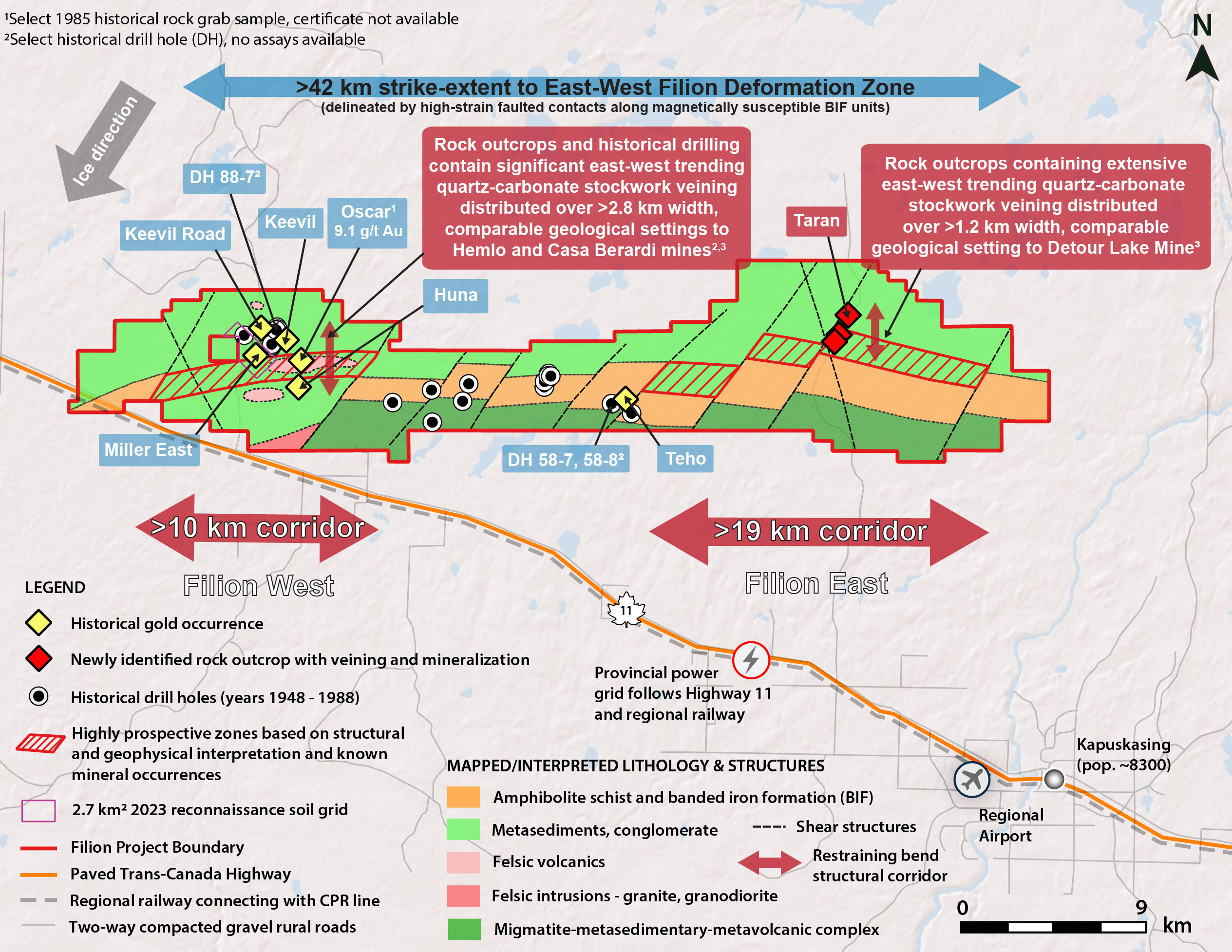
Figure 2. Filion Project boundary with underlying geology annotated with known gold mineral occurrences, select historical rock grab sample assays and drill holes.
Project Geology - Largely Underexplored
The Filion Project is located in a highly prospective largely underexplored geological region where gold was first discovered in the 1930’s, followed by isolated exploration efforts consisting of trenching, power stripping, and drilling until the 1980’s. Despite encouraging results indicating a large-scale fertile geological setting, including a gold bearing structure, none of this work was systematic and regional geochemical soil sampling was never conducted.
Historical work did confirm that the Project area is underlain by a greenstone belt of Archean-aged metavolcanic and metasedimentary rocks with metamorphic grades increasing from upper greenschist to amphibolite facies, transected by a major ductile shear zone (Filion Deformation Zone); a metamorphic transition boundary and structural setting known to host significant gold deposits within the region (Figure 1). Within the Project area strong structural controls to quartz-carbonate veining in addition to four Archean bedrock units have been identified that support the prospectivity of the exploration model (Figure 2):
- Major east-west trending deformation zone with associated hydrothermal alteration and pyrite-arsenopyrite mineralization coincident with dilational restraining bends in the deformation zone, the plunge of the associated folding steepens to the west and shallows to the east. Subsidiary northeast-trending quartz-carbonate veining and mineralization is also evident;
- Greenschist facies metasedimentary assemblage consisting of greywacke, arkose, and banded iron formation (BIF) in fault contact with amphibolite facies metavolcanics composed of amphibolite, schists, and amphibole-pyroxene plagioclase gneiss;
- Migmatite-metasedimentary-metavolcanic complex consisting of supracrustal, metavolcanic, and minor metasedimentary rocks, and mafic and granite gneiss; and
- Felsic intrusive suite consisting of massive granite, foliated granite, and granite pegmatite.
Surficial deposits of glacial till cover most of the Project area with sparse outcrop. Till was deposited during several pulses of the Wisconsin glaciation, with the principal advances being orientated 220° and 160° to the southwest and southeast. Work to date has confirmed the presence of outcrop at surface in the vicinity of the historical gold occurrences in the western portion of the project, where historical drilling indicates a shallow variation in till depth from 2 to 21 metres, which is ideal for geochemical humus sampling and drilling. Field work in 2023 also confirmed that till deposits thin within the eastern portion of the Project where the Taran occurrence was discovered (Figure 2).
Torr Exploration 2023 Work
Torr has recently completed reconnaissance field work on the Filion Project, including the collection of 318 humus soil samples (covering 2.7 km2) and 83 outcrop channel samples to confirm the highly prospective styles of mineralization, alteration, and host lithology that were historically reported in the Project area.
Exploration Targeting and Regional Geophysical Comparisons
Torr has recently completed reconnaissance field work on the Filion Project, including the collection of 318 humus soil samples (covering 2.7 km2) and 83 outcrop channel samples to confirm the highly prospective styles of mineralization, alteration, and host lithology that were historically reported in the Project area.
Within the regional greenstone belts early syn-volcanic aged gold deposits are found within major east-west trending deformation zones (Figure 1: Hemlo, Greenstone, Casa Berardi, Detour Lake) that delineate significant contacts between stratigraphic assemblages that often contain magnetically susceptible banded iron formation ± intermediate to mafic intrusions ± pyrrhotite mineralization; expressed as linear high magnetic geophysical signatures. Within these deformation zones the chief emplacement control for gold consists of structural restraining bends as well as competency contrasts along major stratigraphic contacts, both of which have been identified on the Filion Project, together with styles of alteration, mineralization, and host lithology that are permissive for precious metal endowment.
In addition to highly prospective host lithology and a major east-west trending deformation zone the Company has also identified geophysical traits that bear strong comparisons to the Hemlo, Casa Berardi, and Detour Lake Mines as follows:
- Filion West (Figure 2): A >10 km structural corridor that encompasses a major structural restraining bend within the Filion Deformation Zone (Figure 2) that lies between two east-west trending high magnetic linear geophysical anomalies caused by nearby banded iron formation (Figure 2). This style of reduced geophysical response in the total magnetics in proximity to a significant deformation zone is comparable to the structural corridors that host gold mineralization at the Hemlo3 and Casa Berardi mines4.
- Filion East (Figure 2): Multiple discrete linear east-west trending high magnetic anomalies occur within a second interpreted restraining bend within the Filion Deformation Zone that spans >19 km strike-length. At the Taran occurrence pyrite-arsenopyrite mineralization in proximity to metasediment-quartz feldspar porphyry contacts north of the high magnetic geophysical signature associated with the Filion Deformation Zone suggests strong correlations to the geological setting at Filion West. The Teho occurrence differs in geological setting from Filion West and the Taran occurrence as it is hosted within higher-strain and magnetically susceptible sections of the interpreted Filion Deformation Zone to the south; where a high magnetic geophysical signature is likely a result of significant pyrrhotite encountered in historical drilling that yielded trace gold. This is a comparable setting to the Sunday Lake Deformation Zone, where the high magnetic geophysical signature is attributed to the susceptibility of pyrrhotite which is directly associated with gold mineralization at the Detour Lake mine4.
1Leite et al. 2021. Detour Lake Operation Ontario, Canada NI 43-101 Technical Report. Kirkland Lake Gold Ltd. Effective date December 31, 2020. Although the alteration and style of mineralization and geophysics observed at Filion are similar to Detour Lake, the Company is not inferring that they may be indicative of similar precious metal endowment or assays.
2Luhta, L. 1985. Ontario Ministry of Natural Resources, Timmins. Resident Geologist files T-0201.
3Cox et al. Technical Report on the Hemlo Mine, Marathon Ontario, Canada, NI 43-101 Report, April 25, 2017. Although the alteration and style of mineralization and geophysics observed at Filion are similar to Hemlo, the Company is not inferring that they may be indicative of similar precious metal endowment or assays.
4Devriese S, Witherly K. (2018). Patterns in geology and geophysics for Abitibi greenstone-hosted gold deposits. Conference: Society of Economic Geologists. Keystone Colorado, USA, May 2018. Although the geology and geophysics observed at Filion are similar to Casa Berardi and Detour Lake, the Company is not inferring that they may be indicative of similar precious metal endowment or assays.
QP Statement
Michael Dufresne, M.Sc., P.Geol., P.Geo., serves as a Technical Advisor and is the Qualified Person, as defined by National Instrument 43-101, responsible for reviewing and approving the technical content of all materials publicly disclosed by Torr, including the contents of this website.