-
Projects
Kolos Copper-Gold Project
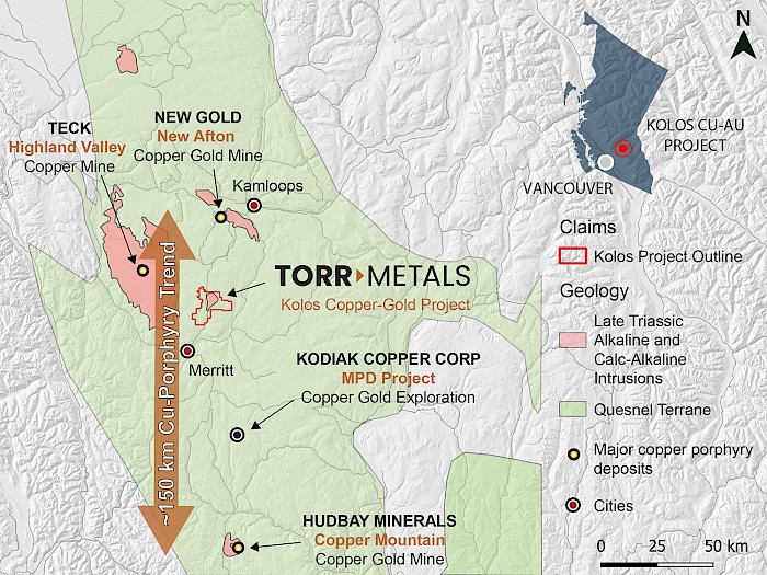
Located within British Columbia’s primary copper producing belt in the prolific Quesnel Trough the 100% owned ~140 km2 Kolos Copper-Gold Project contains Nicola Belt geology along-trend and with similar attributes to alkaline and calc-alkaline copper ± gold ± molybdenum porphyry mines at Copper Mountain, Highland Valley, and New Afton. The project is adjacent to Highway 5 with year-round drive-on access and operation potential provided by numerous forestry service roads and substantial infrastructure provided by the city of Merritt located 23 km to the south. The project contains 6 copper and gold occurrences that have never been drill tested, providing highly prospective exploration targets with significant discovery potential.
Figure 1. Map of the Kolos Project location relative to major porphyry mines at Highland Valley, New Afton, and Copper Mountain.
Project History – Multiple Copper-Gold Targets Never Drill Tested
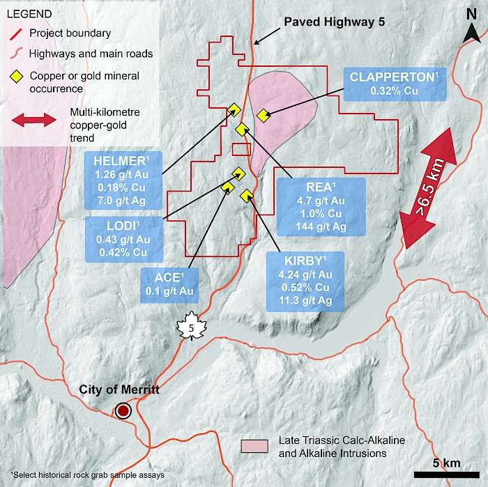
The Project lies within the Quesnel Terrane, a prolific porphyry belt in British Columbia that is host to major deposits and long-lived mines that within the region largely consist of Late Triassic calc-alkaline and alkaline intrusions, including the Highland Valley (30 km to the northwest), New Afton (30 km to the north), and Copper Mountain (106 km to the south) deposits (Figure 1). Regional exploration occurred in the immediate area starting in the 1960’s through to the late 1980’s as a result of the porphyry copper-molybdenum discoveries at Highland Valley. There has been at least 10 operators within the Kolos Project area since the 1960’s that defined 6 significant copper and gold occurrences that have been named the Ace, Kirby, Lodi, Rea, Helmer, and Clapperton occurrences (Figure 2). Intermittent historical work at these occurrences includes rock and soil geochemical sampling, trenching, and EM geophysical surveys.
Figure 2. Kolos Project boundary with known copper and gold mineral occurrences annotated with select historical rock grab samples.
Kolos Copper And Gold Occurrences – Potential For Significant New Discovery
Kirby
Rare outcrop at the Kirby occurrence consists of epidote-chlorite–altered volcanics cut by dioritic dike with north-trending fractures hosting disseminated chalcopyrite and pyrite with malachite staining. A rock sample (013) taken from the discovery of the Kirby occurrence in 2014 assayed 4.24 grams per tonne gold, 11.3 grams per tonne silver and 0.516 per cent copper (Assessment Report 35097).
Another zone of historical mineralization is noted ~500 metres east-southeast of the Kirby occurrence near the Coquihalla Highway, with exposures of andesite tuff and diorite hosting quartz-carbonate veins with pyrite, chalcopyrite and malachite. In 1988, four rock samples (128744, 128742, 128696 and 128699) taken from this outcrop exposure yielded 0.14, 0.60, 0.89, 0.22 grams per tonne gold across a 400 metre north-south trend (Assessment Report 118042).
Lodi
Locally the Lodi occurrence contains andesite hosting crosscutting fracture zones along the north-trending Fanta fault with narrow quartz carbonate veins, up to 0.25-metre wide, and weak to trace malachite ± chalcocite, chalcopyrite and pyrite mineralization. Magnetite is also reported in the area with a rock sample collected in 1988 (128748) yielding 0.60 gram per tonne gold, 4.8 grams per tonne silver and 0.233 per cent copper (Assessment Report 18042). Another zone of mineralization is located ~1 kilometre east of the main occurrence, near the Coquihalla Highway, and comprises an andesite to diorite breccia and granodiorite dikes hosting calcite stringers, pyrite and weak malachite where another outcrop rock grab sample from 1988 (239796) yielded 0.425 gram per tonne gold, 1.8 grams per tonne silver and 0.415 per cent copper (Assessment Report 18042).
Lithology
The Coquihalla Highway separates the two main lithologies encountered on the Kolos Project. West of the highway and in the northeast section of the property andesitic rocks of the Late Triassic Nicola Group predominate, consisting of andesite hornblende porphyry as well as andesitic tuff, lapilli tuff, agglomerate and volcanic breccias. Within the northern portion of the property Nicola Group volcanics are intruded by a fine-grained diorite that is apparently a subvolcanic equivalent of the andesite and is gradational to andesite even on the outcrop scale. East of the highway a Jurassic granodiorite batholith of the Coast Intrusive Complex intrudes and is largely in fault contact (Fanta Fault) with the Nicola Group volcanics. A foliated Late Triassic to Jurassic coarse-grained diorite to quartz diorite to monzonite intrusion is also exposed on the northeast portion of the property and along the western margins of the granodiorite batholith; historically this intrusion has been identified as similar in age and composition to the Iron Mask Batholith, which hosts porphyry style copper-gold deposits south of Kamloops.
Structure
A major north trending structural corridor (Fanta Fault) is exposed along the Coquihalla Highway and for the most separates Nicola Group volcanic and sedimentary rocks to the west from the batholith to the east. The fault is characterized by brecciation, pyritization, carbonate and epidote alteration, local clay alteration and variable silicification. Multiple subsidiary structures cut across the Fanta Fault trending 125 degrees and are typically pyritic, silicified zone with local clay alteration. This northwest-southeast trend is associated with mineralization and intrusive orientations in the northern portion of the project area at the Helmer and Clapperton occurrences. Other fracture and shear orientations include northeast to easterly.
Mineralization & Alteration
Highly prospective mineralization consists of locally abundant pyrite that is disseminated within host volcanics as well as concentrated within north-trending fault structures that separate the underlying Late Triassic Nicola Group rocks from Late Triassic granodiorite to quartz monzonite intrusions. Elsewhere throughout the project area localized occurrences of malachite with rare chalcopyrite also occur within host Nicola Group volcanics, associated with increased fracturing together with carbonate alteration and quartz-carbonate veinlets. These veinlets carry malachite, pyrite ± chalcocite that together with observed alterations styles is suggestive of the upper level of a large-scale copper porphyry system with near-surface exposure.
QP Statement
Michael Dufresne, M.Sc., P.Geol., P.Geo., serves as a Technical Advisor and is the Qualified Person, as defined by National Instrument 43-101, responsible for reviewing and approving the technical content of all materials publicly disclosed by Torr, including the contents of this website.


