-
News
Torr Announces Staking of Gold Endowed 261 km² Ontario Project and Provides Latham Update
October 26, 2023
Vancouver, British Columbia (BC) – (October 26, 2023) – Torr Metals Inc. (“Torr” or the "Company") (TSX-V: TMET.V) is pleased to announce the staking of the district-scale highway-accessible Filion Gold Project (the “Project”) totaling 26,076 hectares (~261 km2) encompassing a significant 42 kilometre (km) east-west trending deformation zone (the “Filion Deformation Zone”); associated with 6 known historical gold occurrences hosted within an underexplored greenstone belt in northern Ontario. Additionally, Torr has completed reconnaissance field work on the Project including the collection of 318 humus soil samples and 83 outcrop channel samples to confirm the highly prospective styles of mineralization, alteration, and host lithology that were historically reported in the Project area. The 100% owned Filion Gold Project is located within a prolific region of northern Ontario that hosts a number of major gold mine producers with deposits occurring in comparable geological settings (Figure 1). The Project is ideally situated adjacent to excellent infrastructure with the town of Kapuskasing located ~30 km to the southeast and direct road access 4 km from the Trans-Canada Highway, regional railway, and provincial power grid.
Highlights of Historical and 2023 Fieldwork:
- District-scale opportunity with >42 km strike-length to the major east-west trending Filion Deformation Zone that remains largely untested, with 6 known historical gold occurrences already defined across multiple structural corridors; this includes a highly prospective dilational bend of the deformation zone that yielded 9.1 grams per tonne (g/t) gold (Au) in a historical rock grab sample1 (Figure 2).
- Potential for significant new gold discoveries in a prolific Tier 1 mining jurisdiction, minimal exploration within the Project area largely consisted of locally concentrated historical trenching, power stripping of rock outcrop, and drilling (~23 drill holes consisting of 4,100 metres project-wide). Torr is the first to ever conduct a geochemical soil sampling program in the Project area, with a systematic modern approach that will test potential for identifying and vectoring potential gold anomalies.
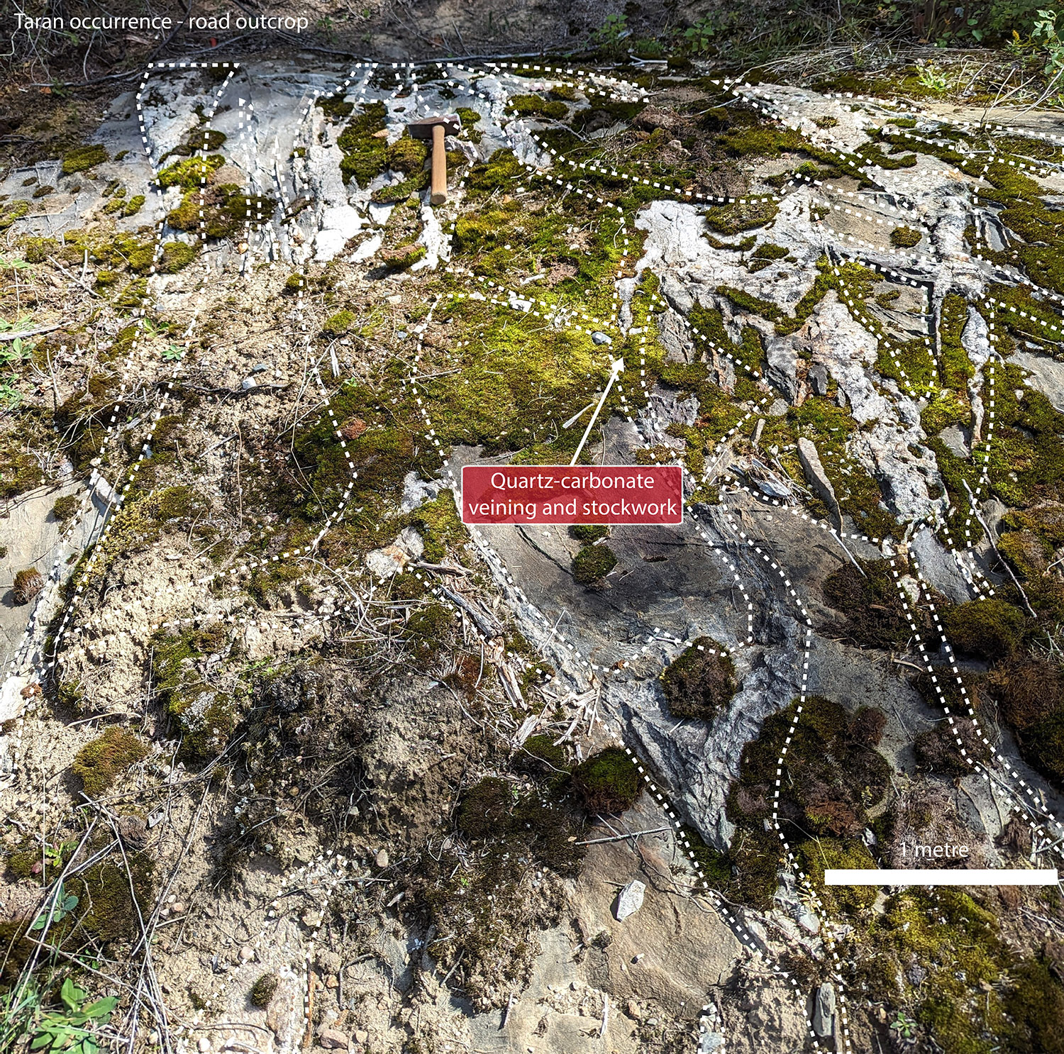
- Newly identified prospective targets demonstrate potential for new district-scale discovery upside potential, Torr is the first to ever conduct exploration reconnaissance in the Taran occurrence area (Figure 2, 3) and was able to quickly identify 3 road outcrops distributed across 1.2 km that contained extensive east-west trending quartz-carbonate stockwork veining (Figure 3) hosting pyrite and arsenopyrite mineralization. Increased abundance in veining and mineralization was also observed in proximity to a quartz-feldspar porphyry contact with metasediments at the main occurrence. This style of veining together with chlorite-sericite-silica-fuchsite alteration suggests a fertile geological setting that is associated with gold endowment within the region.
- Assays pending for 318 humus samples (covering 2.7 km2) and 83 rock channel samples, the latter taken from outcrop at the Miller East and Taran occurrences (Figure 2).
Malcolm Dorsey, President and CEO, commented, “Through staking the Filion Project we have acquired 100% ownership of a significant district-scale gold system that is road-accessible and only a few kilometres from the Trans-Canada Highway, with substantial nearby infrastructure that will provide low-cost year-round operation potential within a prolific mining region. We are very excited to be at the forefront of potential new discoveries in a vastly underexplored district and look forward to sharing results from our initial geochemical reconnaissance work, designed to test modelled structural controls and potential scalability of known gold mineralization. This is the first geochemical program of its kind in this area and as such positive results will provide a strong foundation and momentum for future exploration.”
Figure 1. Filion Project location within the prolific gold-endowed greenstone belts of the Wabigoon, Wawa, and Abitibi subprovinces of northern Ontario. Figure includes the positions as well as total historical and forecasted production of major regional gold mines.
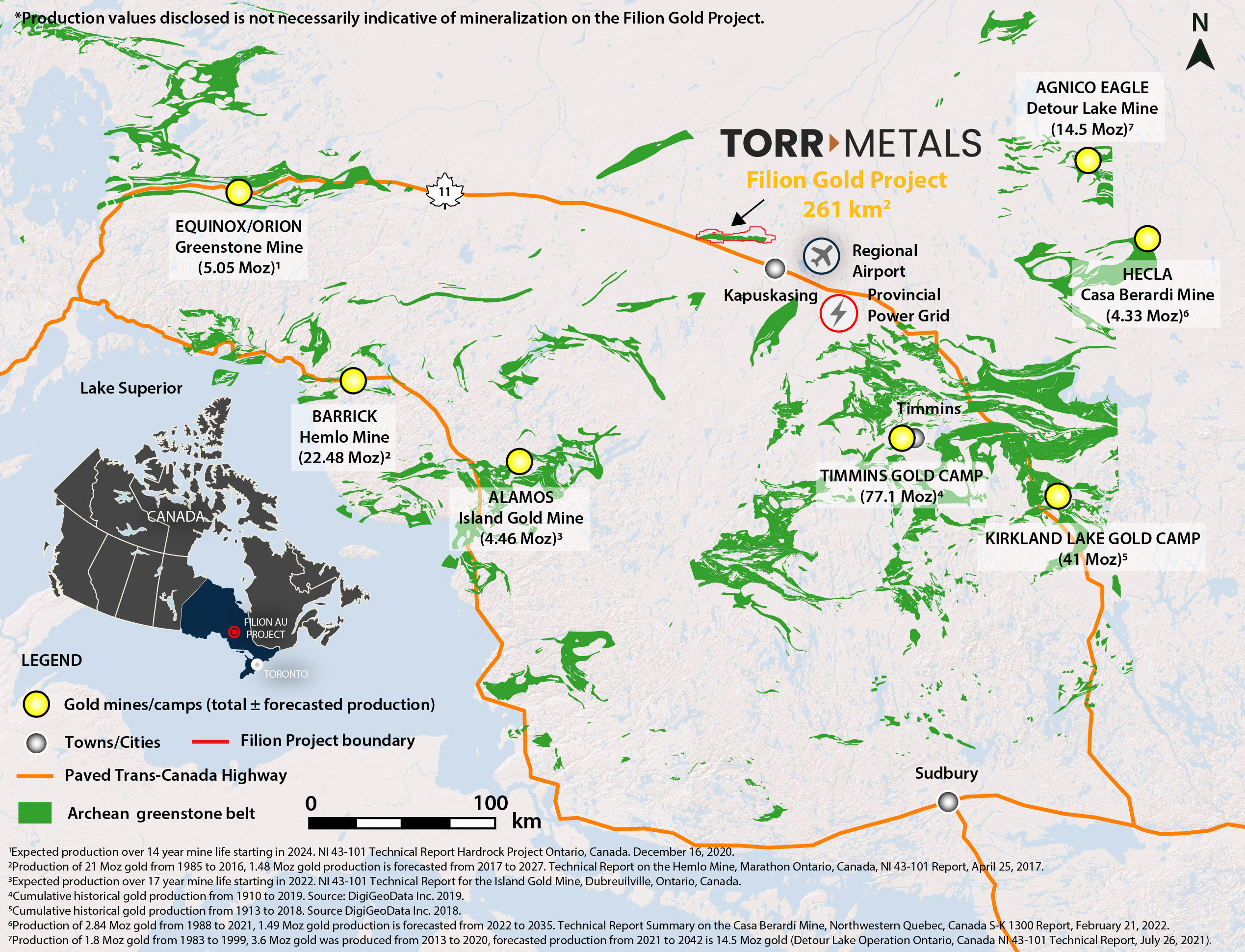
Figure 2. Filion Project boundary with underlying geology, annotated with known gold mineral occurrences and select historical rock grab sample assays and drill holes.
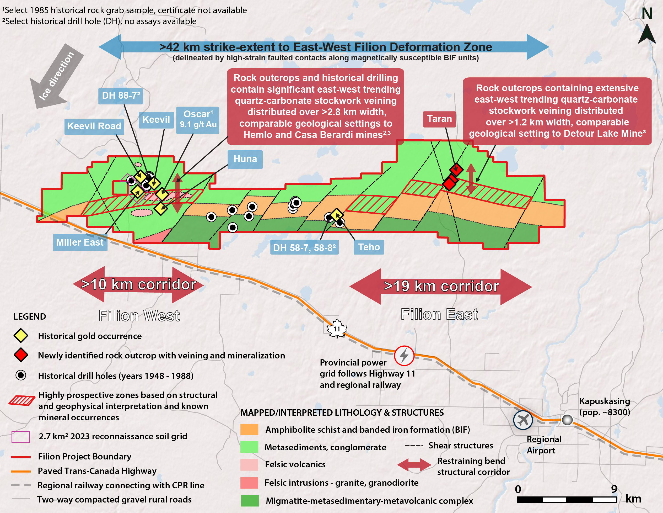
Figure 3. Taran occurrence road outcrop with rock hammer for scale. Outcrop contained abundant quartz-carbonate stockwork veining within a metasediment host proximal to a quartz-feldspar porphyry contact. Outcrop has never been historically sampled and is identical in style of veining, mineralization, and alteration to historical gold occurrences within the western portion of the Filion Project.
Filion Project Geology
The Filion Project is located in a highly prospective largely underexplored geological region where gold was first discovered in the 1930’s, followed by isolated exploration efforts consisting of trenching, power stripping, and drilling until the 1980’s. Despite encouraging results indicating a large-scale fertile geological setting, including a gold bearing structure, none of this work was systematic and regional geochemical soil sampling was never conducted.
Historical work did confirm that the Project area is underlain by a greenstone belt of Archean-aged metavolcanic and metasedimentary rocks with metamorphic grades increasing from upper greenschist to amphibolite facies, transected by a major ductile shear zone (Filion Deformation Zone); indicating a significant metamorphic transition boundary and structural setting known to host significant gold deposits elsewhere within the region (Figure 1). Within the Project area strong structural controls to quartz-carbonate veining in addition to four Archean bedrock units have been identified that support the prospectivity of the exploration model (Figure 2):
- Major east-west trending deformation zone with associated hydrothermal alteration and pyrite-arsenopyrite mineralization coincident with dilational restraining bends in the deformation zone, the plunge of the associated folding steepens to the west and shallows to the east. Subsidiary northeast-trending quartz-carbonate veining and mineralization is also evident;
- Greenschist facies metasedimentary assemblage consisting of greywacke, arkose, and banded iron formation (BIF) in fault contact with amphibolite facies metavolcanics composed of amphibolite, schists, and amphibole-pyroxene plagioclase gneiss;
- Migmatite-metasedimentary-metavolcanic complex consisting of supracrustal, metavolcanic, and minor metasedimentary rocks, and mafic and granite gneiss; and
- Felsic intrusive suite consisting of massive granite, foliated granite, and granite pegmatite.
Surficial deposits of glacial till cover most of the Project area with sparse outcrop. Till was deposited during several pulses of the Wisconsin glaciation, with the principal advances being orientated 220° and 160° to the southwest and southeast. Work to date has confirmed the presence of outcrop at surface in the vicinity of the historical gold occurrences in the western portion of the project, where historical drilling indicates a shallow variation in till depth from 2 to 21 metres, which is ideal for geochemical humus sampling and drilling. Field work in 2023 also confirmed that till deposits thin within the eastern portion of the Project where the Taran occurrence was discovered.
Filion Project Historical Drilling
Approximately 298 metres of drilling was conducted in 1988 within the Project area in the vicinity of the Keevil occurrences2 and although there are no assay results available there are indications of strong hydrothermal alteration in the drill logs that could be permissive for precious metals. Drill hole (DH) 88-7 (Figure 2) intercepted quartz veining associated with variable amounts of pyrite-arsenopyrite mineralization and silica-sericite-tourmaline alteration hosted by metasediments from 16.7 metres to the end of hole at 89.9 metres. Veining and alteration is associated with contacts between metasediments and a quartz-feldspar porphyry. Within this interval a section from 49.4 metres to 60.3 metres is reported to contain extensive quartz veining with moderate to strong silicification and sericitization together with enhanced pyrite-arsenopyrite mineralization. These styles of historically reported alteration and mineralization together with the lithological and structural characteristics were confirmed by 2023 channel sampling of outcrop at the nearby Miller East occurrence and are typical of brittle-ductile structurally related regimes such as the Hemlo deposit, where gold was transported within hydrothermal fluids that exploited the quartz-feldspar porphyry-metasediment interface within a restraining bend of a regional ductile deformation zone3 (Figure 1).
The Teho occurrence is defined by drill holes 58-7 and 58-8 (~248m)4 that both intercepted a sulphide zone within interbedded quartz sericite schist, gneissic amphibolites, and greenschist facies metasediments (Figure 2). Drill hole 58-7 reported quartz veining and replacement sulphides within metasediments from 48.8 metres to 89.9 metres. Within this interval is a section of enhanced quartz veining (~60% of core) with chlorite, epidote, silica alteration and pyrrhotite-pyrite-chalcopyrite (predominantly pyrrhotite) mineralization that yielded trace gold and silver from 70.1 metres to 89.9 metres. Although follow-up drilling was never conducted the style of alteration and mineralization together with the close spatial relationship to faulted stratigraphic contacts and shear zones represents a favourable geological setting comparable to the Lower Detour Lake Formation contact with the Sunday Lake Deformation Zone, which hosts the Detour Lake mine5.
1Luhta, L. 1985. Ontario Ministry of Natural Resources, Timmins. Resident Geologist files T-0201.
2Smith, R.G. 1988. Drilling Report McCowan. File ID 42G10SE0001.
3Cox et al. Technical Report on the Hemlo Mine, Marathon Ontario, Canada, NI 43-101 Report, April 25, 2017. Although the alteration and style of mineralization and geophysics observed at Filion are similar to Hemlo, the Company is not inferring that they may be indicative of similar precious metal endowment or assays.
4Cyprus Exploration Corp. 1958. Drilling Report Idington. File ID 42G10SW0011.
5Leite et al. 2021. Detour Lake Operation Ontario, Canada NI 43-101 Technical Report. Kirkland Lake Gold Ltd. Effective date December 31, 2020. Although the alteration and style of mineralization and geophysics observed at Filion are similar to Detour Lake, the Company is not inferring that they may be indicative of similar precious metal endowment or assays.
Exploration Targeting and Regional Geophysical Comparisons
Within the regional greenstone belts early syn-volcanic aged gold deposits are found within major east-west trending deformation zones (Figure 1: Hemlo, Greenstone, Casa Berardi, Detour Lake) that delineate significant contacts between stratigraphic assemblages that often contain magnetically susceptible banded iron formation ± intermediate to mafic intrusions ± pyrrhotite mineralization; expressed as linear high magnetic geophysical signatures. Within these deformation zones the chief emplacement control for gold consists of structural restraining bends as well as competency contrasts along major stratigraphic contacts, both of which have been identified on the Filion Project, together with styles of alteration, mineralization, and host lithology that are permissive for precious metal endowment.
In addition to highly prospective host lithology and a major east-west trending deformation zone the Company has also identified geophysical traits that bear strong comparisons to the Hemlo, Casa Berardi, and Detour Lake Mines as follows:
- Filion West (Figure 2): A >10 km structural corridor that encompasses a major structural restraining bend within the Filion Deformation Zone (Figure 2) that lies between two east-west trending high magnetic linear geophysical anomalies caused by nearby banded iron formation (Figure 2). This style of reduced geophysical response in the total magnetics in proximity to a significant deformation zone is comparable to the structural corridors that host gold mineralization at the Hemlo and Casa Berardi mines6.
- Filion East (Figure 2): Multiple discrete linear east-west trending high magnetic anomalies occur within a second interpreted restraining bend within the Filion Deformation Zone that spans >19 km strike-length. At the Taran occurrence pyrite-arsenopyrite mineralization in proximity to metasediment-quartz feldspar porphyry contacts north of the high magnetic geophysical signature associated with the Filion Deformation Zone suggests strong correlations to the geological setting at Filion West. The Teho occurrence differs in geological setting from Filion West and the Taran occurrence as it is hosted within higher-strain and magnetically susceptible sections of the interpreted Filion Deformation Zone to the south; where a high magnetic geophysical signature is likely a result of significant pyrrhotite encountered in historical drilling that yielded trace gold. This is a comparable setting to the Sunday Lake Deformation Zone, where the high magnetic geophysical signature is attributed to the susceptibility of pyrrhotite which is directly associated with gold mineralization at the Detour Lake mine6.
6Devriese S, Witherly K. (2018). Patterns in geology and geophysics for Abitibi greenstone-hosted gold deposits. Conference: Society of Economic Geologists. Keystone Colorado, USA, May 2018. Although the style of geology and geophysics observed at Filion are comparable to Casa Berardi and Detour Lake, the Company is not inferring that they may be indicative of similar precious metal endowment or assays.
Latham Project 2023 Fieldwork and Permit Update
Starting with the earliest possible engagement at the beginning of 2022 and spanning approximately 19 months management of the Company navigated a significant consultation process regarding the Latham Project, with proposed mitigation strategies for affected Indigenous groups and communities. During this period management was optimistic and fully committed to engaging in an open and respectful dialogue and believed significant strides were made to address the concerns and expectations of all stakeholders, with the process resulting in the preparation of draft permits by the Ministry of Energy, Mines and Low Carbon Innovation and a bond payment by the Company. While all efforts were made and a positive outcome was expected, the Company was at this time unfortunately denied the issuance of a final permit for the Latham Project (see Tahltan Central Government news release dated September 21, 2023). While the Company respects the decision-making process and all parties involved, management noted a lack of clarity in the explanation for the permit denial provided by the Ministry of Energy, Mines and Low Carbon Innovation. Management believes it is crucial for all stakeholders and the mining industry as a whole to understand how these decisions balance the diverse interests and rights of all parties involved, including a clear and comprehensive rationale. The Company intends to thoroughly review all feedback and reasoning behind the permit denial and adapt its plans accordingly. Aimed at gaining insight into the permit decision-making process, the Company has submitted an information request pursuant to the Freedom of Information and Protection of Privacy Act (the “FOI Request”). Although this process normally takes up to 30 days the Company has been notified that the FOI Request has been delayed to the middle of next year (2024) and as such will be submitting a complaint to the Information and Privacy Commissioner; management is committed to transparency and intends to share further insights once available. As a result of field work completed in 2023, including 1412 soil and 75 rock samples collected, the core targets on the Latham Project will remain in good standing until late 2028.
Qualified Person
The technical content of this news release has been reviewed and approved by Michael Dufresne, M.Sc., P.Geol., P.Geo., a consultant to the Company who is a qualified person defined under National Instrument 43-101.
About Torr Metals
Torr Metals is a Vancouver based mineral exploration company focused on defining and developing its diversified copper-gold project portfolio with the substantial exploration potential of the ~261 km2 Filion Gold Project in northern Ontario and 140 km2 Kolos Copper-Gold Project, located within the prolific Quesnel Terrane in Central British Columbia. Year-round road access is provided by Highway 11 (Trans-Canada) and Highway 5 respectively, with the projects being based out of the towns of Kapuskasing, Ontario and Merritt, BC. For further details about ongoing exploration work and the Company’s additional 689 km2 Latham Copper-Gold Project please refer to the Company's website or current geological Technical Report (August 24, 2021) filed on November 25, 2021 under the Company's profile on SEDAR at www.sedar.com.
On behalf of the Board of Directors
Torr Metals Inc."Malcolm Dorsey"
Malcolm Dorsey
President, CEO and DirectorFor further information:
Malcolm Dorsey
Telephone: 236-982-4300
Email: malcolmd@torrmetals.comNeither the TSX Venture Exchange nor its Regulation Services Provider (as that term is defined in the policies of the TSX Venture Exchange) accepts responsibility for the adequacy or accuracy of this press release.
Cautionary Statement Regarding Forward-Looking Information
This press release contains "forward-looking information" within the meaning of applicable Canadian securities legislation. Forward-looking information includes, without limitation, statements regarding the use of proceeds from the Company's recently completed financings, and the future plans or prospects of the Company. Generally, forward-looking information can be identified by the use of forward-looking terminology such as "plans", "expects" or "does not expect", "is expected", "budget", "scheduled", "estimates", "forecasts", "intends", "anticipates" or "does not anticipate", or "believes", or variations of such words and phrases or state that certain actions, events or results "may", "could", "would", "might" or "will be taken", "occur" or "be achieved". Forward-looking statements are necessarily based upon a number of assumptions that, while considered reasonable by management, are inherently subject to business, market and economic risks, uncertainties and contingencies that may cause actual results, performance or achievements to be materially different from those expressed or implied by forward-looking statements. Although the Company has attempted to identify important factors that could cause actual results to differ materially from those contained in forward-looking information, there may be other factors that cause results not to be as anticipated, estimated or intended. There can be no assurance that such information will prove to be accurate, as actual results and future events could differ materially from those anticipated in such statements. Accordingly, readers should not place undue reliance on forward-looking information. Other factors which could materially affect such forward-looking information are described in the risk factors in the Company's most recent annual management's discussion and analysis which is available on the Company's profile on SEDAR at www.sedar.com. The Company does not undertake to update any forward-looking information, except in accordance with applicable securities laws.